


My Favorite Webcams on the Salish Sea
Use these cams to check weather and tides or as a nice office backdrop

I’ve used webcams for years for checking tides, wind and even for tracking freighters for surfing near Seattle.
Marine weather forecast apps aren’t always accurate so it’s nice to have a real time view of a paddling spot to help make trip planning decisions.
I also have friends that display specific webcams in their offices on large screens as a sort of live backdrop.
Do you know of other useful or cool cams along the Salish Sea? Send me a note or post in chat!
Here’s my favorites:
Ballard Elks Paddling Club’s ‘Sunset Cam’ - Book Trip #22
Enjoy passing boats headed to or from the Ballard Locks (to the left) and majestic views of Seattle’s Shilshole Bay and the distant Bainbridge Island and Olympic Mountains. At night you can see the West Point Lighthouse blink off Discovery Park.
This is the beach where I launch my Seattle paddling lessons from. I use it to check tide levels but also to track freighters in the shipping lanes for surfing nearby.

Deep Cove Kayak webcam - Book Trip #79
Deep Cove is in North Vancouver, BC and is easily accessible for kayak and paddle board rentals, tours and instruction. It is also the launch spot for paddling into Indian Arm which is on an incredibly beautiful fjord with undeveloped tree topped islands, a few remote paddle-in campsites and waterfalls.

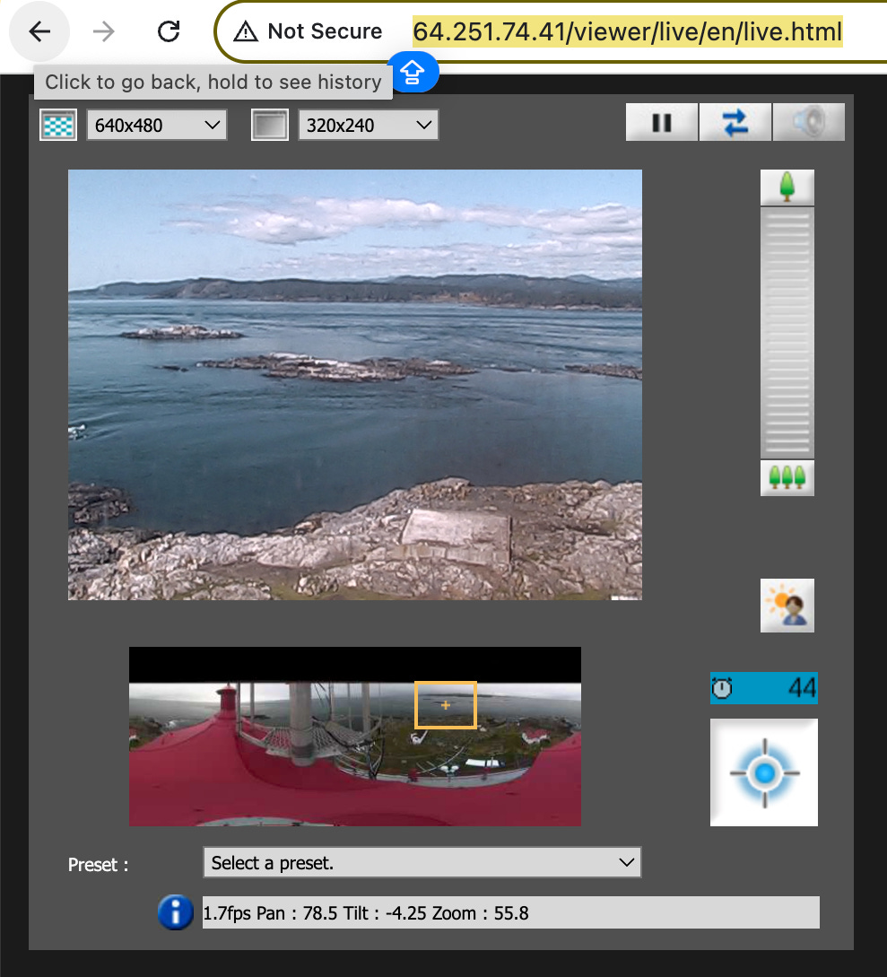
Race Rocks, BC - Trips 67 - 68
Located on the Strait of Juan de Fuca west of Victoria, Race Rocks is a unique lighthouse topped island with it’s own micro climate. Being exposed offshore and where the Strait bends north just to the east, the island experiences heavy ocean swell and tidal current as well as high winds.
If it’s blowing 20 knots in Port Angeles across the way, it’s blowing 40 at Race Rocks. It’s fun to track it’s weather! Just offshore are equally dynamic seas.
You can self-direct the webcam and listen to the sea life on the rocks, it’s a fun one.
Skunk Bay Cam - Trip #24
Despite the cool name, the Skunk Bay cam is a unique one. It has several views to choose from plus all the weather date you could image from air pressure and astronomical info to tides, wind etc.
For those doing the Seventy48 Race, one view is of Foulweather Bluff and the bay below. Great for checking weather for that spot before you get there.

Hoko Cam - Trip #48
Hoko Cam is on the Strait of Juan de Fuca about a hour-ish west of Port Angeles along Highway 112. The cam is at the Hoko River mouth, a bit west of Sekiu. Hoko River is known for an archeology wet site dating back since time immemorial. It’s a good cam to check for west Strait wind and ocean swell activity.

WSDOT (WA Department of Transportation) - Trip # All (in WA)
Not as beautiful as the above cams, the wsdot cams show ferry and road views throughout the Salish Sea. I have the mobile app for checking ferry lines, schedules, whether the Hood Canal bridge is having a marine opening or accident with traffic backed up for miles. Also good for checking weather!

Order my book Paddling the Salish Sea 80 Trips - Paid members get a discount. Founding members receive a signed complimentary copy.
Book Me - I'm available to present my book and related paddling topics. Contact me
I Provide Custom Surf Ski and SUP Coaching
Through my business Salmon Bay Paddle, I offer 1-1 and 2-person personalized paddling lessons for sups and surf skis in the Seattle area and beyond for all skill levels.
Whether starting as a total beginner or as an advanced paddler seeking to refine skills I can help you reach your goals.
I provide training for touring, learning about tidal currents and trip planning, paddling safely in Deception Pass, surfing freighter waves in Seattle and more.
Contact me to chat / Follow me on IG: @salmonbaypaddle