


Ride the Flow: 4 Salish Sea Tidal Streams for Paddlers
Learn where to get a free ride on the Salish Sea

When my students ask me how about tidal current on Puget Sound, I tell them the Sound is just a slow river. This means the current in most areas flows 1 to 3 knots with no rapids creating eddies behind points of land, buildings and rocks.
Unlike a river, the Salish Sea has tides with two ebbs and two floods each flowing for 6 hours. Read my post A Beginner’s Guide to Salish Sea Tides to learn more about how it works.
Once you understand how tides and currents flow work on the Salish Sea, you’ll be able to better understand how to plan trips and make smarter decisions on-water, especially if the current is flowing opposite the direction you’re going.
Quick Tip: Currents are the horizontal flow of water. Tides are the vertical flow of water. I check current tables to see if I can find current flowing in the direction I want to go. I check tides to make sure the beach I want to launch or land at won’t be a mud flat when I arrive.
What is a Tidal Stream?
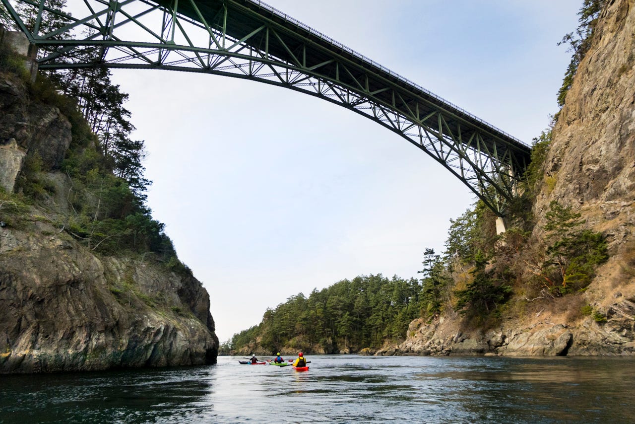
Current flows faster in narrow channels creating a tidal stream. Ever heard of Deception Pass? ‘DP’ as I call it has very narrow channels acting like a bottleneck where saltwater flows through traveling from one bay to another changing directions four times a day.
You can use a tidal streams to get a free ride for fun and/or to speed up your journey if on a longer trip.
Three of the tidal streams listed below are pretty mellow unlike the reputation of Deception Pass.
How is that different from a tidal bore? From Google…
A tidal bore is a wave that travels upstream in a river or estuary, caused by the leading edge of an incoming tide. It's essentially a "tidal wave" that surges against the current, sometimes creating a significant wall of water.
Turnagain Arm near Anchorage, Alaska has a tidal bore that fills the bay in minutes. I experienced it in the fall of 2023 watching local surfers and beluga whales ride in on it!
4 Salish Sea Tidal Streams
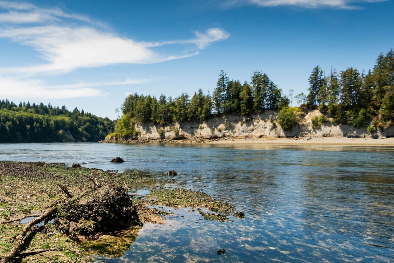
Port Townsend Canal or ‘PT’ Canal
PT Canal separates the Olympic Peninsula by Port Hadlock from Indian Island. Until the 1920’s it was connected at the south end where a Klallam village was located. It was channelized to make way for commercial shipping.
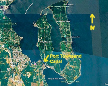
This nearly one mile channel has flows up to 4 knots and can be accessed from a few different spots along it’s length.
Tidal currents are difficult to predict for the channel and I’ve seen it switch directions in a few minutes. Check my book Paddling the Salish Sea for details, (Page 207).
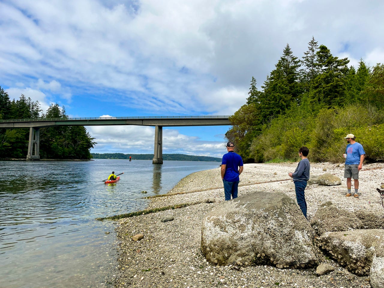
Watch the tidal current in the canal here at about 4 knots (2024)
Seventy48 racers love or hate the channel. Nearing the end of their 70 mile journey to Port Townsend, if they score and get the right flow, it’s a welcome free ride north. If they miss it, there are shore eddies to use or they wait it out.
Hammersley Inlet near Shelton
This is one of my favorite tidal streams with a 5.5 mile from Shelton to Pickering Passage and onwards to camp or spend a few hours exploring Hope Island.
It can be done as an easy day trip taking the ebb out to Pickering Passage or to Hope Island, then take the flood back.

Note: There’s two Hope Islands on Puget Sound, one listed here and the other east of Deception Pass in Skagit County.
The inlet can get up to 5 knots and only has two small spots with mild rapids. At lower tides and bars can appear in the middle of the channel, so I recommend planning for higher tides.
Watch the video of the current flowing here
From Shelton, there’s homes along the shores until just before Cape Horn where forested hillsides rise above the waterway.
Watch out for commercial boat traffic mostly from Taylor Shellfish harvesters and the logging mill at Shelton.
Get more details in my book, this is Trip #1.
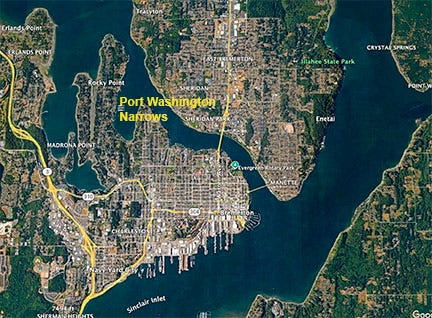
Bremerton’s Port Washington Narrows
Known for it’s century old Naval shipyard and dry docks, Bremerton also has a great tidal stream called the Port Washington Narrows.
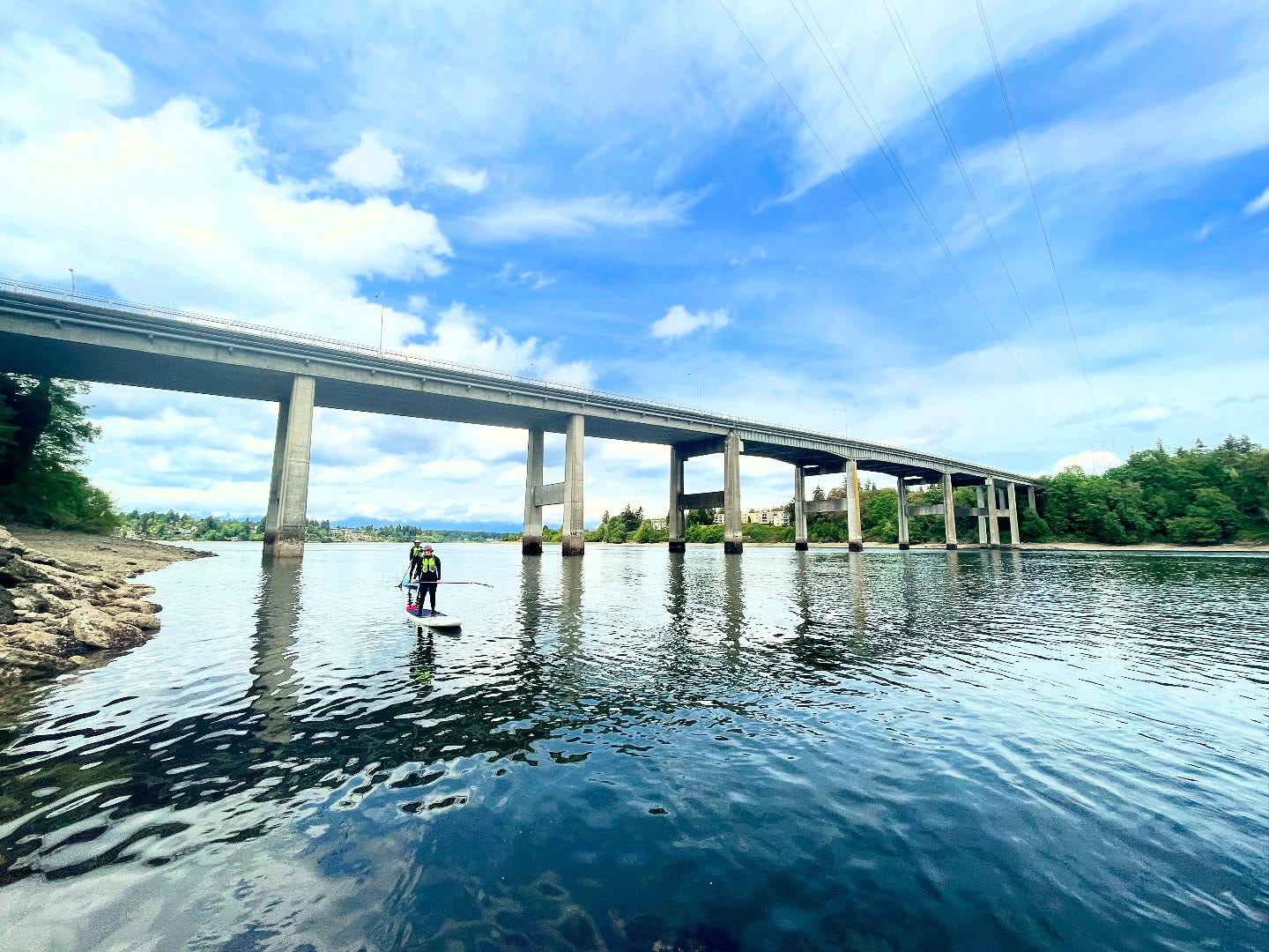
The 3.2 mile waterway can flow up to 4 knots but has only section that can have a light rapid but nothing to worry about. The tidal stream is in a valley of sorts with steep sides topped by homes, apartments and trees.
Usually I like to launch at Lions Park on the flood and use shore eddies to work up stream to the Manette Bridge then take the flood down. I take students there to learn how to paddle in tidal current.
On sunny days enjoy epic views of Mt Rainier to the southeast and the Olympic Mountains to the northwest.
Watch the current flow in this video
Paddle under two bridges and stop for a bite at the Boat Shed Restaurant by Manette Bridge.
Every summer Olympic Outdoor Center hosts a Ride the Tide event for paddlers running the entire length from Tracyton to Port Orchard.
Agate Pass - Kitsap County
Agate Pass is an almost mile long tidal channel separating Bainbridge Island from the Kitsap Pensinula near Poulsbo. The current can run up to 4 knots with few shore eddies to work with.
The Pass is often viewed from the Agate Pass Bridge.
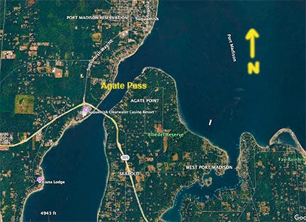
I took two students there last week and as we arrived the flood was moving about 3 knots. We launched at the end of the flood to paddle to the Agate Pass Bridge then worked along the shore against a northerly and a 1 knot ebb back to our launch at Old Man Park.
The waterway has been the Suquamish tribe’s ancestorial land since time immemorial. The tribe still owns the west shore but landing is ok where permitted. Get the Onx Hunt app to check for property lines.

The Suquamish man Seattle was named for, Chief Sealth, lived most of his life in and around these shores. It was reported in the early 19th century there was a 140 foot long house stood at Old Man Park.
Quick Terms:
Eddy: (Not Eddie Van Halen or Money): Current flows around a rock creating a calm area or recirculating current. Used to take a break in current or ‘eddie hop’ upstream.
Ebb - Outgoing Tide.
Flood: Incoming tide
Resources:
I teach sup and surf ski private lessons in Deception Pass and on any of the above listed tidal streams. Contact me to learn more.
Get my book Paddling the Salish Sea 80 Trips to learn where to paddle and about water access, tidal current details and more.
NOAA Tides App, I also use the Navionics app to determine tidal current predictions.
Book: Tidal Currents of Puget Sound, Starpath.com
Book Me - I'm available to present my book ‘Paddling the Salish Sea’ or related paddling topics. Contact me
I Provide Custom Surf Ski and SUP Coaching
Through my business Salmon Bay Paddle, I offer 1-1 and 2-person personalized paddling lessons for sups and surf skis in the Seattle area and beyond for all skill levels.
Whether starting as a total beginner or as an advanced paddler seeking to refine skills I can help you reach your goals.
I provide training for touring, learning about tidal currents and trip planning, paddling safely in Deception Pass, surfing freighter waves in Seattle and more.
Contact me to chat / Follow me on IG: @salmonbaypaddle
PSUPA Flat Water 1 SUP Instructor Certification Course
New Date!! June 21-22 in Seattle I’m holding this two day in-depth course to train you to become a professional stand up paddle board coach.
Receive the PSUPA 80 page training manual. Contact me for more info. Course Details / PSUPA