


Using Tidal Current to your Advantage
Learning how the tidal current works on Puget Sound and the Salish Sea will greatly benefit your forward progress.

The waters of the Puget Sound and the rest of the Salish Sea are tidal dependent thus learning how they work will really benefit your trips.
Have you ever paddled on a flat calm day but wondered why you’re going slower than usual and feel you’re on a treadmill? This means you were probably paddling against tidal current.
If you’re near shore, there’s a method of using tidal current to your benefit vs fighting it. This is especially helpful if you’re racing in the Seventy48 or WA360 and are hoping to make good time without getting burned out.
The Basics of Tidal Current in the Salish Sea -
Without getting to crazy here’s a few super basics of how tides and current runs here.
Basic Terms to Know..
Ebb - Outgoing current.
Flood - Incoming current.
Tides - Vertical movement of water. We have a semi-Semidiurnal cycle meaning we have two 6 hour ebbs and two 6 hour floods.

Tidal Current - Horizontal movement of water. Current mostly moves in timing with the tides but not always right on the money. The first hour of current can start slowly then ‘max’ out in speed at 3 hours, then slow down. So it’s a rise to a peak, then down again. In the last hour it can bump up a bit, then end moving into slack..
Slack - Is a period of chill between each cycle, usually lasting ten to twenty minutes. Folks in Deception Pass use the slack to more safely pass through the Pass with less or no current.
Slack can happen sooner if there’s been recent heavy rain, if wind is pushing the current faster and/or if a local river nearby is at flood stage.
Tip: Don’t always trust tide and current tables. On the Strait of Juan de Fuca tides near Port Angeles are often an hour or two ahead of printed or online tide tables. Locals use the Peninsula Daily News tide tables instead. Don’t be a slacker and do your research and make final decisions on location.
Tidal Current Can be Weird
In Deception Pass, the main Pass on the south side below the bridge can still be moving while Canoe Pass on the north side could be totally calm like a lake. Use my book to find out the complexities of tides/currents in specific spots.
Other weird spots include Colvos Passage west of Vashon that generally only runs north. Burrows Island is usually flooding when you’d think it should be ebbing. I’ve seen Port Townsend' ‘PT’ Canal flooding hours before it’s predicted time.
Using Tidal Current to your Benefit -
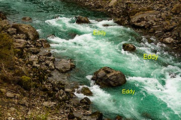
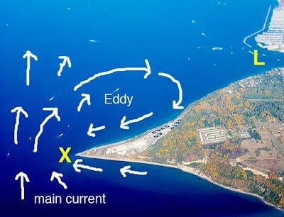
Eddies (but not Eddie Money, Val Halen or Vedder)
The Puget Sound is a big class 1 river which means it’s always moving but isn’t fast enough to create rapids except in very-narrow canyon like spots such as Deception Pass where current runs swiftly.
When the tide ebbs (outgoing) or floods (incoming) around points, headlands or other obstructions sticking out, the current refracts around the point thus creating a swirl of current behind. This swirl of sorts also creates an eddy directly behind the obstruction.

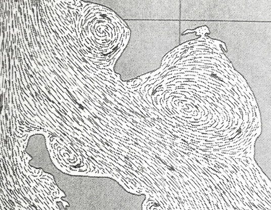
An ‘eddy’ is an area of calm or reverse circulating water on the opposite side of the obstruction. Paddlers can use eddies to rest or work their way up or down a river linking eddies together. Eddies can occur in light or fast current.
In Deception Pass there’s spots such as behind Pass Island where on the ebb, we can paddle up the eddy several hundred feet with current flowing in the opposite directions on both sides.
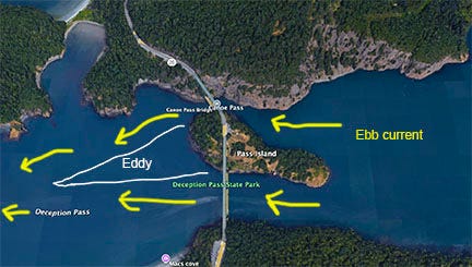
Tip: People freak out when we speak about paddling in Deception Pass. Because well informed paddlers can use eddies to move upstream (and can portage) we have more control there than boaters who have to stay in deep water channels with more current.
Using Current to Move Forward -
The swirl I mentioned above that wraps around points can work for you or against.
If you’re paddling along the shore to a point and current hits a point and wraps around the back side, you can use the inside swirl to give yourself a touch of a push to the point. If you’re offshore a bit you’ll hit the direct current and get into sticky water.
Read how these concepts are put to use below..
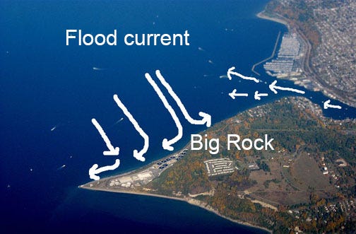
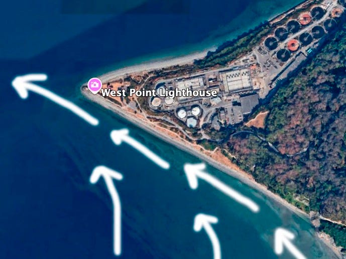
Seattle’s Shilshole Bay - Case Study -
West Point which juts out into the Sound from Magnolia creates eddies on both sides during ebbs and floods.
If it’s ebbing, paddling to the point from Ballard along the shore may give you a touch of help or at least a break from paddling in current which will be felt more slightly offshore.
Paddling back to Ballard away from the point - it made makes more sense to be offshore a bit to take advantage of the current wrapping around vs closer to shore where the current is going the reverse direction against you.
You can test this as I have during paddling races or with friends with no wind where paddlers are headed towards the point from Ballard with one along the shore, and another about 100 feet offshore. If paddling the same stroke rate, who gets there sooner with less effort?
While training two rowers for the Seventy48 last March, we approached PT Canal along the west shore north of Mats Mats Bay to avoid the flood and north wind in the canal. We made good time with little resistance then popped through the canal using eddies along the shore. I’ll do a post on that section of the race at some point.
Wind Around Points - The same affect is applied here with a strong wind.
On the north side of Magnolia, if flooding, the current splits at the big erratic boulder below DayBreak Star Center. This means you’ll experience sticky water from the point to the rock along the shore and a push on the east side of the rock towards Salmon Bay. There’s always current flowing out of Salmon Bay below the Locks, which is a dam.
Another interesting effect – The other day I was surfing wind waves at the point on the ebb. Strong ebb current backed by a 20-knot southerly was flowing along the south shore from Discovery Park to the point thus pushed me straight out into the Sound instead of wrapping around the point.
Meadow Point at Golden Gardens has this same effect for ebb or flood, south or north wind.
Resources:
Puget Sound Tidal Currents (book) by David Burch, Starpath.com
My book - Paddling the Salish Sea, 80 Trips, Mountaineers Books. Check out the tides/currents section edited by kayaking coach Robert Nissenbaum.
Tide / Currents Lesson - Give me a holler for a lesson on the above. I can also help with specific routes you planning to paddle including the Seventy48 and WA350 races. I also teach in Deception Pass which is a great spot for learning how to read water.
Tides / Currents Guides:
NOAA West Point Station - Despite all the wind apps out there, I still use this page which seems more reliable. Observations are made hourly. Learn about air pressure as well monitor. If it’s dropping - wind is building, weather ‘worsening’. Click on Latest Marine Forecast too.
Use the page to check other ‘buoys’ around the Sound. I use the Port Angeles, Neah Bay and La Perouse buoys to check ocean swell, wind etc for surfing the Strait.
For British Columbia’s South Coast, Canada use this link.
I use NOAA’s tides app and save my ‘favorite locations.’
There’s a few sites for fishing folks that work as well. Use what works for the way you think. I’m a bit dyslexic and like visual graph guides more than numbers.
Navionics - Great app for tides, currents and more. More reliable than Deep Zoom.
Captain’s - A great online bookstore that used to have a shop in Seattle. Check out this link for a bunch of helpful guides. I’m a big fan of the Evergreen Publishing’s tide table Calendars. I keep the Puget Sound one one me for planning classes and trips.
I Provide Custom Surf Ski and SUP Coaching
Through my business Salmon Bay Paddle, I offer 1-1 and 2-person personalized paddling lessons for sups and surf skis in the Seattle area and beyond for all skill levels.
Whether starting as a total beginner or as an advanced paddler seeking to refine skills I can help you reach your goals.
I provide training for touring, learning about tidal currents and trip planning, paddling safely in Deception Pass, surfing freighter waves in Seattle and more.
Contact me to chat / Follow me on IG: @salmonbaypaddle
Related Posts:
Capturing the Salish Sea: My Kayak Camera Setup for Epic Paddling Adventures
Nighttime Paddling: Essential Tips for After-Dark Adventures
Great article, Rob. It's been so interesting to figure out where the find the eddys as I boat/SUP around Olympia. In particular, around Hope Island/Squaxin Island/Boston Harbor area. With all the different inlets that current can can be a wild ride.